California is reeling from a powerful atmospheric river storm that has turned deadly, dumping months’ worth of rain in just days and triggering widespread flash flooding. As of November 15, 2025, the intense weather system has claimed two lives, prompted evacuation warnings, and heightened risks in wildfire-scarred areas. With heavy rains peaking on Saturday and lingering threats into early next week, millions of residents face a perilous start to the rainy season.
An atmospheric river—a narrow corridor of concentrated moisture in the sky—began slamming the Golden State on Friday, bringing relentless downpours, gusty winds, and heavy mountain snow. Forecasters predict the storm will deliver several months’ typical rainfall in a short span. In Southern California, cities like Los Angeles could see 3 to 5 inches of rain through Monday, compared to an average of just over 6 inches from November to January. San Diego might receive 2 to 3 inches by Sunday, nearly matching its seasonal norm of about 4 inches.
The storm’s intensity escalates on Saturday, with peak rainfall expected between 4 a.m. and 12 p.m. Pacific Time. Rain rates could reach one inch per hour, accompanied by thunderstorms and a slight chance of weak tornadoes. The FOX Weather Center has issued a level 3 out of 4 flash flood threat through Sunday morning, affecting over 20 million people under Flash Flood Watches.
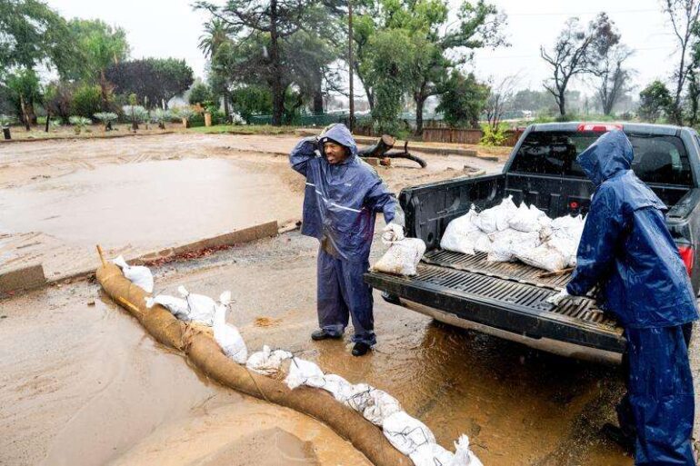
Particularly vulnerable are regions scarred by recent wildfires. Burn scars—areas where wildfire ash creates a water-repellent layer on the soil—prevent proper absorption, leading to rapid runoff, flash floods, landslides, and debris flows. Evacuation warnings are in place near the Pacific Palisades, Eaton, Franklin, Easton, and Canyon fire zones from earlier this year. Saturated ground statewide amplifies the danger, as even non-burn areas risk sudden flooding.
Tragically, the storm has already proven fatal. In Carmel, a father drowned while attempting to rescue his 5-year-old daughter, who was swept out to sea; the child remains missing. In the Sacramento area, a 71-year-old delivery driver perished when floodwaters on the Pleasant Grove Creek Bridge swept his Mazda into a creek. He called 911, but rescuers arrived too late as the vehicle fully submerged. The driver was pulled out unresponsive and could not be revived.
By late Saturday night, the heaviest rains should shift eastward into southern Nevada, including Las Vegas. However, risks persist: an upper-level low weakens on Sunday, but another system could renew flash flooding in Northern California. By Monday, only scattered showers are expected in the south.
High in the Sierra Nevada, winter weather alerts are active, with some mountain passes already closed for the season. Ridgetop wind gusts may top 100 mph, and feet of snow could accumulate in the highest elevations.
This event could rank as one of Los Angeles’ wettest Novembers in five decades if forecasts hold. As California transitions into its wet season, this atmospheric river serves as a stark reminder of nature’s power—and the heightened vulnerabilities in a fire-ravaged landscape. Residents are urged to heed evacuation orders, avoid flooded roads, and stay informed through official alerts.