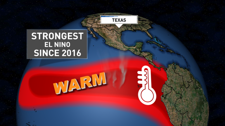
El Niño is developing in the Pacific Ocean more quickly than forecasters predicted, and the odds are growing that it could become a powerful “Super” El Niño by this fall or winter.
According to the latest update from NOAA’s Climate Prediction Center, there is a two-in-three chance that the event will reach strong or very strong levels at its peak. This natural climate pattern occurs when sea-surface temperatures in the central and eastern tropical Pacific rise significantly above average, altering wind patterns and weather around the globe.
What Is El Niño?
El Niño is a recurring climate cycle that typically happens every two to seven years and lasts nine to 12 months. It is measured by how much warmer than normal the ocean waters become in a key region of the equatorial Pacific. Once temperatures rise more than 0.5°C (about 0.9°F) above average for an extended period, weak El Niño conditions are declared. A “Super” El Niño occurs when waters warm by more than 2°C (3.6°F) above average.
These warmer waters trigger widespread changes: some regions face drought and heat waves that increase wildfire risk and strain water supplies, while others experience heavy flooding. El Niño can also weaken the Atlantic hurricane season while making the Pacific hurricane season more active. On top of human-caused global warming, strong El Niños tend to push worldwide temperatures even higher.
Faster Development and Growing Confidence
Right now, average water temperatures in the monitored Pacific zone sit just below the 0.5°C threshold. However, NOAA now expects them to rise above it by next month — a faster timeline than projected in last month’s outlook, which had favored neutral conditions through June.
Forecasters say El Niño is likely to strengthen through the summer and fall. There is now a 96% chance it will continue through the Northern Hemisphere’s winter, making its development nearly certain.
The increased confidence comes from a large buildup of warm water deep in the central and eastern Pacific. This warm pool is expected to rise to the surface and fuel further strengthening.
While the formation of El Niño looks increasingly likely, there is still some uncertainty about exactly how strong it will become. Still, the probability of a Super El Niño during the November-to-January peak period has risen from about 25% last month to roughly 33% now.
Some climate models are showing the possibility of this becoming one of the strongest El Niños on record. The last Super El Niño occurred in 2015–2016, which remains the strongest since reliable records began in 1950. Other notable strong events took place in 1997–1998, 1982–1983, and 1972–1973.
What It Could Mean for Weather
Even if this event stops short of “Super” status, it is still expected to be a strong El Niño, which usually produces more pronounced global effects.
- Hurricanes: Strong El Niños often create conditions that suppress tropical storm and hurricane development in the Atlantic, while increasing activity in the central and eastern Pacific. This could bring more threats to Hawaii and parts of the U.S. Southwest.
- United States: During winter, much of the northern U.S., western Canada, and Alaska typically see warmer-than-average temperatures, though cold snaps can still occur. The southern U.S. often experiences wetter and cooler conditions as a stronger jet stream directs more storms through the region.
- Global Impacts: Reduced monsoon rainfall is common in India and Southeast Asia. The Caribbean frequently faces worsening drought, and parts of southern and eastern Asia tend to have warm, dry winters. Southeast Africa may see increased drought risk during its summer months (December to February).
On the temperature front, this El Niño is loading the odds in favor of 2026 or 2027 becoming one of Earth’s warmest years on record. NOAA has already stated it is very likely that 2026 will rank among the five warmest years, even before fully factoring in El Niño’s extra warming effect.
While El Niño’s impacts are significant, they do not always follow the exact same pattern. For example, the 2015–2016 Super El Niño brought severe drought to the Caribbean as expected, but did not deliver the unusually wet winter that Southern California often sees during such events.
Forecasters will continue monitoring ocean and atmosphere conditions closely in the coming months, as the exact strength and impacts of this El Niño will become clearer over time.